Some mountains are closed today, Saturday, December 20 due to the storm. See Mountain Status
Sugarloaf Mountain Guide
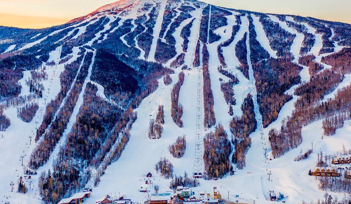
Here at Mainely Skiing, we are all about skiing and ease of use at different mountain resorts. Sugarloaf is an incredible mountain if you want terrain with Burnt Mountain over to West Mountain, and everything in between. Prepare for an awesome day at Sugarloaf!
Mountain Stats:
Take in all that Sugarloaf has to offer.
Base elevation: 1,417′
Summit elevation: 4,237′
Vertical drop: 2,820′
Annual average snowfall: 200″
Number of chairlifts: 15
Named runs: 176
Skiable acreage: 1,360
Acres of glades: 100+
Number of beginner terrain trails: 34
Longest run: 3.5 miles (Tote Road)
Pass: New England
Getting To Sugarloaf:
Approximate driving time from major metro areas (in hours):
Portland, ME: 2:30
Bangor, ME: 2:10
Montreal: 3:30
Quebec City: 3:20
Boston, MA: 4:10
Hartford, CT: 5:30
New York City: 7:30
Lift Information:
Lifts are open at 8:30am to 3:45pm with the exception of King Pine and Whiffletree, which open at 9:00am midweek, Timberline at 9:00am daily, and Snubber at 8:00am weekends and holidays. They close on a staggered schedule as follows:
Whiffletree: 3:50
SuperQuad: 3:50
Bucksaw Express: 3:50
King Pine: 3:50
Timberline: 3:50
Skyline: 3:50
Snubber: 3:45
Skidway: 3:50
Sawduster: 3:50
Double Runner East: 3:50
Double Runner West: 3:50
West Mountain: 3:30
CVA/Colby T-Bar: On Demand
Bateau T-Bar: On Demand
Moosecalator: On Demand
Trails:
All trails at Sugarloaf are thoughtfully designed with skiing and snowboarding in mind. Take a cruiser down Tote Road or warm up on Whiffletree. Whatever you are into, Sugarloaf has trails that side best with you! While looking at the trails below, look for that special symbol, as those are Keegan’s favorite trails and the ones he recommends.
Key: – Easy, Beginner – More Difficult, Intermediate – Most Difficult, Advanced – Extremely Difficult, Experts Only – Keegan’s Favorite Trails
Base Area:
The Sugarloaf base area is serviced by three lifts and one carpet. All the trails are groomed and this area is separated from the more advanced upper mountain terrain creating a peaceful mountain environment. There is a little parking lot at the base of the Snubber chair and will be on a first-come, first-served basis and will fill up fast! Please note, to use this area, you must have a pass to use the lift.
The trails serviced from this chair include:
All trail names and descriptions. To view a high-resolution 2025-26 Sugarloaf trail map click here.
Natalie’s Birches – A short trail serviced by Sawduster. This trail can take you to the Sugarloaf Inn with food, bathrooms, and a phone. Snowbrook – This is a nice, long, flat run that takes you all the way down to the base of Snubber. You pass through the Snowbrook village and other mountain homes. You will definitely need push at the end. The Landing – This trail is serviced by the Skidway chair and is a good warm-up before you hit either Double Runner or Whiffletree.
Photo: Maine Drone Imaging
Double Runner Area:
The Double Runner area is a beginner area along with a race training trail. Most of the trails are groomed and this area is mostly separated from the more advanced upper mountain terrain creating a peaceful learning environment.
The trails serviced from this chair include:
All trail names and descriptions. To view a high-resolution 2025-26 Sugarloaf trail map click here.
Boardwalk – The main trail and the trail under the lift. A very wide trail for learning. Lower Narrow Gauge – This trail sometimes has good jumps on the side of the trail. If you are looking for a fun little run, I would recommend this trail. Lower Winters Way – The trail just before Dropline. Normally not groomed but awesome on a powder day. Picaroon – This trail is hard to find but a good one if it’s open. Schipper’s Streak – The end of Sidewinder, also a hard-to-find trail but is always fun. Middle Narrow Gauge – Serviced by DRW, this trail is a short extension of the bigger race trail serviced by the SuperQuad or Skyline. Tote Road X-Cut – A short little trail to give Tote Road more length. You can get most of this from the SuperQuad.
Photo: Maine Drone Imaging
SuperQuad Area:
The SuperQuad loads mountain right out of the base area and is the main lift up the mountain. The chair serves a nice variety of upper-level green and black-level terrain and some excellent glades can be accessed. You can access the upper-level Timberline lift via the Bridle Chain trail.
The trails serviced from this chair include:
All trail names and descriptions. To view a high-resolution 2025-26 Sugarloaf trail map click here.
Lower Tote Road – End of the road for this trail. Don’t underestimate the fun of this trail. Peavy X-Cut – A cross-cut from Tote Road which can take you all the way over to Whiffletree. Bridle Chain – A little shortcut to the Timberline Chair. Can get rutted up but is a fun mogul trail. Candy Side – Candy Side can be accessed by the Peavy X-Cut or by Hayburner. This is a nice long run which can give you good speed. Gin Pole – From the top left of SuperQuad, Gin Pole is a short trail that takes you to Skyline. King’s Landing – This is a really nice winding trail that will deliver good speed. Shhh… this trail almost always has good conditions. Lower Binder – This trail is accessed by Lower Scoot off of Windrow. Lower Competition Hill – A wide, and curvy racing trail. Closed when races are happening. Takes you to Sidewinder. Pinch – The main trail/unload area off of the SuperQuad. Can take you to Tote Road. Spurline – A short trail off of Tote Road which takes you to Lower Double Bitter and Candy Side. Haywire – This trail is right after the big headwall on Tote Road. A smooth and easy trail, perfect for people who want a little more speed than what Tote Road can offer. Lower Double Bitter – After following Spurline, Lower Double Bitter is a nice cruiser that takes skiers back to the Candy Side trail. This trail used to be called Stomping Grounds. Ram Pasture Glade – This glade is off of the Haywire and Lower Tote Road Trails. This is a fun glade to hit when the other people in your group want to do groomers and you want to do the trees. Double Bitter – This thin trail isn’t groomed so anything can happen. Perfect after a powder day! Sidewinder – This is the wide trail you can see from the SuperQuad which typically has big snow features on it. Hayburner – This steep trail earns its name of the burner. Although, I think it should be called leg burner – especially when there are moguls. Kickback – The trail near Upper Skidder and Hayburner. Lower Sheerboom – When this trail is open, it is a blast. This is the trail that the SuperQuad lift runs up. Sheerboom – When this trail is open, it is a blast. This is the trail that the SuperQuad lift runs up. Swedish Fiddle Glade – This tight glade is located in between Hayburner and King’s Landing. Upper Competition Hill – One of the race trails at Sugarloaf. Branding Ax Glade – This very short glade is nestled in between the Double Bitter and King’s Landing Trails. Lower Skidder – Less steep, this trail joins in with the Peavy X-Cut or Candy Side Upper Skidder – The widest trail and is right next to the unload of the SuperQuad.
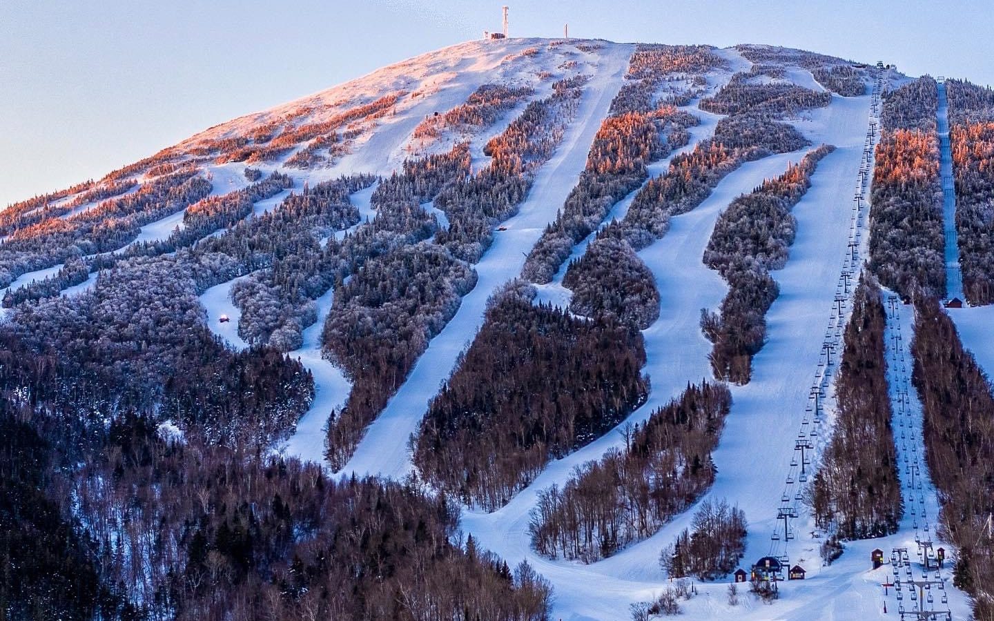
Photo: Maine Drone Imaging
Skyline Area:
Skyline loads mountain left of the top bullwheel on Double Runner East. The chair serves a nice variety of upper-level blue and black-level terrain and some excellent glades can be accessed. You can access the Timberline lift via the Tote Road trail.
The trails serviced from this chair include:
All trail names and descriptions. To view a high-resolution 2025-26 Sugarloaf trail map click here.
Gondola Line – This is the wide trail that the Sugarloaf Gondola Ran up. Most commonly referred to as Gondi Line. Lower Spillway – The trail that the Skyline Quad runs up. Midstation X-Cut – Going from Sluice all the way across the mountain to Ramdown. Pick Pole – This cutoff trail that runs to Timberline. Sluice – The big trail mountain left of Spillway. Tote Road – Meet up with the Tote Road Ext. for 3.5 miles of skiing enjoyment. Blade Glade – In between Upper Bubblecuffer and Upper Boomauger. Cant Hook Glade – Right near Upper Boomauger. Gondi Glade – Mountain left of Gondola Line, that patch of trees. Kurf Glade – Near the base/load area of Skyline. Lower Bubblecuffer – Runs all the way down to the meet up with the Lombard X-Cut. Sluice Chute – The first trail to the mountain right after the bullwheel of Skyline. Sluice Headwall – The trail near the cheese graters (wind grates) Spillway X-Cut – Mountain left after the unload of Skyline, this takes you all the way to the top bullwheel of King Pine. Stump Shot – In between Upper Winter’s Way and Upper Gondola Line. Upper Binder – Near the Timberline chair and can be used as a shortcut. Upper Double Bitter – This trail is to the side of the Tote Road Ext. Upper Narrow Gauge – One of the race trails at Sugarloaf. Upper Spillway – The trail that the Skyline Quad runs up. Wedge – Will meet up with Lower Bublecuffer and get to the end of Lombard X-Cut. West Sluice Chute – This fast short trail will lead into Sluice. Cribworks – In between Upper Narrow Gauge and Upper Competition Hill. Upper Bubblecuffer – Follow the spillway X-Cut. Upper Gondola Line – The wide trail that the old Sugarloaf Gondola ran up. Upper Winters Way – Ungroomed and mountain right of the top bullwheel of Skyline. White Nitro – All the way down. The trail after Upper Bubblecuffer.
Photo: Maine Drone Imaging
Whiffletree Area:
Whiffletree loads mountain left of the base area. The chair serves a nice variety of green and blue level terrain with some black diamonds sprinkled in for good measure. You can access the King Pine chair from the Tohaul Trail.
The trails serviced from this chair include:
All trail names and descriptions. To view a high-resolution 2025-26 Sugarloaf trail map click here.
Condo X-Cut – This trail cuts across the mountain and ends on Lower Stubs Cross Haul – A trail that leads all the way to Lower Whiffletree. Lower Pole Line – That straight trail that ends by the base of the Whiffletree Quad. Lower Stubs – Lower Stubs is a condo trail that takes you around the outside of the mountain and finishes in a village off the Snubber Lift. Lower Whiffletree – The easiest way down, you can step into various terrain parks or glades. Rollway (EWD) – This trail leads into either Upper Pole Line, Upper Springboard, or Upper Whiffletree. Skybound – This trail is directly under the Whiffletree lift and features Sugarloaf’s Small terrain park. The Yard – The Yard is where the old tubing park used to be and also has a terrain park on the trail. Upper Stubs – Coming off of Upper Buckboard, this trail goes around the various glades. Blueberry’s Grove Glade – The glade in between Upper Skid Road and Upper Whiffletree. Jackpot Glade – This glade is in between Upper Skid Road and Upper Buckboard. Jill Poke – The wide trail under the upper part of the lift. Lombard X-Cut – This cross-cut leads over to the loading area of Skyline and is wicked fun to fly around the mountain. Lower Buckboard – Take the scenic route around the terrain parks but will still lead back to the base of Whiffletree. Lower Cruiser – This trail is nice if you want an easy way down from Whiffletree. Lower Rookie River Glade – This glade will come out onto Slasher. Lower Springboard – Another tight trail that is similar to Lower Pole Line. Moose Alley – Moose Alley is a perfect trail for the kids. With the mascot’s homes off of the side of the trail, this is perfect for a private ski trail. Slasher – A trail that leads back to the base lodge or the Double Runner chairs. Tohaul – Coming from the base of King Pine, this trail is good if you get there and realize that lift is on Wind Hold. Upper Buckboard – A trail right on the tree line of some awesome beginner glades. Upper Cruiser – This trail is nice if you want an easy way down from Whiffletree. Upper Pole Line – This straight trail that ends by the base of the Whiffletree Quad. Upper Springboard – Right off the top of Whiffletree. Upper Whiffletree – The main trail down and the trail named after the lift. Broccoli Garden Glade – I could go on and on about how amazing this glade is. The top is a little sketchy for intermediate skiers but once you’re in, it’s amazing! The glade drops you on the Cross Haul Trail and brings you back to Whiffletree. Stubs Glade – In between the Stubs trail and Condo X-Cut. Upper Rookie River Glade – In the woods from the Lombard X-Cut all the way to the Condo X-Cut.
Photo: Maine Drone Imaging
King Pine Area:
King Pine is the furthest left lift on the mountain. This chair has the steep, fun stuff along with Brackett Basin which is an awesome set of glades.
The trails serviced from this chair include:
All trail names and descriptions. To view a high-resolution 2025-26 Sugarloaf trail map click here.
Lower Boomauger – This trail takes you to Rollaway and Upper Whiffletree. Old Winter’s Way – A cut trail that leads to Ramdown and Upper Boomauger. Ramdown – The easiest way down from the King Pine chair. Choker – Mountain right to the King Pine Quad. Flume – Breaking away from the Widowmaker Trail, this trail will lead into the Tohaul trail. Freds Pitch Glade – This glade is in between the Choker and Haulback trails. Haulback – The main trail which runs right under the King Pine chair. Experts will be watching! Upper Boomauger – In between Flume and Widowmaker. This will drop you out at the top of Whiffletree. Boomers Glade – Located near the top of the Whiffletree unloading area and accessed by Widowmaker, this short but steep glade is built for thrill seakers. Widowmaker – A trail that leads you into either Flume or back to the top of Whiffletree. Misery Whip – A straight shot down the mountain. This trail is in between Ramdown and Widowmaker. Ripsaw – This ungroomed trail takes you near the entrance to Brackett Basin and along the tree line.
Photo: Maine Drone Imaging
Timberline Area:
Timberline is the only lift servicing above tree skiing in the east. On a sunny March day, you won’t want the day to end! You can access the Timberline chair from the Bridle Chain Trail. This lift also gives access to the Snowfields.
The trails serviced from this chair include:
All trail names and descriptions. To view a high-resolution 2025-26 Sugarloaf trail map click here.
Lower Timberline – If you keep going on Timberline, you will connect up with Bullwinkle’s. Upper Timberline – My favorite trail off of the Timberline lift. You can access glades, black diamonds, and the green Timberline trail if the others want to ski greens. Buckskin – A short little trail that takes you from the Tote Road Ext. to the base of the Timberline Chair. Cinderhoe – The trail that not many people use. It’s under the lift. Tin Pants – Right under the chair for everyone to see! Tote Road Ext. – The start of the 3.5 mile journey down the mountain. Barberchair Glade – One of the best glades off of Timberline. This follows the trail almost the entire way down and spits you out right before the loading terminal of Timberline. This glade is also referred to as Pipe Cleaner. Binder Ext. – The Black diamond is right next to Upper Timberline. Dropline Glade – This tight glade is in between the lift line and the Timberline trail. Narrow Gauge Ext. – Dipping into the Snowfields, despite the double black, this isn’t a hard trail.
Photo Maine Drone Imaging
West Mountain Area:
West Mountain is the furthest right trail pod on the mountain. The pod is serviced by two lifts, Bucksaw Express, and the West Mountain Double. It serves a nice variety of green and blue-level terrain and private condos and homes. You can access the West Mountain trail pod from the Tote Road Trail.
The trails serviced from this chair include:
All trail names and descriptions. To view a high-resolution 2025-26 Sugarloaf trail map click here.
Birch Hook – A little trail off of Tote Road leading into Bullwinkle’s. Bucksaw X-Cut – A shortcut trail that can take you to Upper Scoot or Bullwinkle’s Bucksaw – This is the trail that takes skiers from Lower Glancer back to the base of Bucksaw Express. You can take this trail if you choose to boot up at your car in the trailside parking lots. Good Chance X-Cut – A straight trail leading to Horseshoe. Horseshoe – A trail that loops around the top unloading area of the Bucksaw Express to get skiers back to the main mountain. Hatchet – Accessed by the Upper Glancer trail, this trail brings skiers back to the Feller-Buncher trail. Bucksaw – This trail comes from Lower Glancer and takes skiers around the Sugarloaf Real Estate area. Feller-Buncher – The main trail under the Bucksaw Express lift. Cutter – This trail can be accessed by the Horseshoe trail, it takes skiers back to the Feller-Buncher trail. Chipper – Chipper takes you around Bullwinkle’s and brings skiers to the West Mountain trail pod. Whistle Punk – A nice flowy trail that takes skiers from the crosscuts on West Mountain back to the base of the Bucksaw Express. Upper Beaver Tail – This trail connects the Upper West Mountain trail to the Whistle Punk trail. Lower Beaver Tail – This trail brings Upper Beaver Tail and Knot Bumper together before bringing skiers to Whistle Punk. Knot Bumper – A short trail that comes from Chipper and Upper West Mountain. It takes skiers to the Lower Beaver Tail trail. Extension of Horseshoe – This extension of Horseshoe gets people around the top of Bucksaw and back to the Horseshoe trail. Yarder – Yarder is a flowing trail that leads to Whistle Punk. Twitcher – This trail takes skiers from the Yarder trail and brings them to the Whistle Punk trail. West Mountain Crosscut – A trail that brings skiers from the Lower West Mountain trail to the Bucksaw Express. This is the last place to turn off or you’re stuck riding the West Mountain double. Lower Glancer – A narrow-cut trail that takes you to condos and to the Bucksaw trail. Lower Scoot – Lower Scoot can take you to condos by the SuperQuad. Lower Binder – This straight shot of a trail gets fed by Lower Scoot and Condos and takes skiers back to the base of the SuperQuad. Lower West Mountain – A trail that takes you along the lift and along the West Mountain homes. Lower Windrow – The lower part of Windrow that brings skiers back to the condos or to the SuperQuad. Middle Scoot – A winding trail that if you time it right, you can cut right back into Tote Road and avoid the flat, push back to SuperQuad. Upper Glancer – A Steeper trail that will lead to Scoot. Windrow Ext – A very short trail that leads to Bullwinkle’s Boom Scooter – Boom Scooter is a short little connector trail that goes from Lower Glancer and Windrow. Greenhorn Glade – Greenhorn Glade is a condo glade that not many people take. Take this trail after a powder day just make sure you make it back onto the West Mountain trail before reaching the roads. Upper Scoot – This trail is one of the main trails out of Bullwinkle’s Upper West Mountain – A long trail alongside the West Mountain homes and condos. Upper Windrow – This trail is one of the main trails out of Bullwinkle’s Raker Tooth Glade – A short glade off of Upper Windrow.
Photo: Lift Blog
Terrain Parks:
Sugarloaf Terrain Parks are some of the best in the state. Follow @sugarloafparks on Instagram to see park updates and changes. suugarloafparks.instagram
Park SMART: Start Small – Work your way up. Make a Plan – Every feature. Every time. Always Look – Before you drop. Respect – The features and other users. Take it Easy – Know your limits. Land on your feet.
The terrain parks include:
All trail names and descriptions. To view a high-resolution 2025-26 Sugarloaf trail map click here.
Drop Line (L/XL) – Just below the Skyline Quad, this is Sugaroaf’s expert park with Large and Extra Large Features. Watch the pros or try some for yourself. Sidewinder (BX) – Located off the SuperQuad, Sidewinder is the go-to place for features made out of snow. This is the place where the Banked Slalom takes place. Upper Tote Park – This early season park gets set up on Upper Tote Road and hike from the unloading area of the SuperQuad. Skybound (S) – Located under the Whiffletree lift, this short and small terrain park is built for beginners learning how to ride. Jill Poke (S/M) – Just after the unloading area of the Whiffletree Quad, this park gets skiers and riders into the narrow terrain park life. Also known as Snake Run. Cruiser (M) – Located on the Cruiser trail, this park features medium-sized features with jumps, rails, boxes, and more! Follow the terrain park crew to stay in the loop with any changes to this park! The Yard (M/L) – Located near the bottom of Whiffletree, this park changes quite frequently. Make sure to follow the terrain park crew on Instagram (@sugarloafparks)
Uphill Travel:
Sugarloaf has multiple different uphill options. Please pay attention to all safety alerts, trail signs, and updates before going uphill. All uphill travel is done at the individual’s own risk. For the most current information on the uphill trail status, look at their mountain report page: sugarloaf.com
The uphill trails include:
All trail names and descriptions. To view a high-resolution 2025-26 Sugarloaf trail map click here.
Starting From Base – Ascend Windrow following uphill markers to the Bucksaw trail. Starting From Lots E, F, and G – Ascend Bucksaw Trail, follow route markers before making a right onto Backcut (Trail is not listed on trail map but marked with uphill signage). Ascend through Backcut intersection (Hatchet and Cutter Trails) onto Feller Buncher trail; west to Beaver Tail, Knot Bumper, and then across West Mountain Trail onto Chipper. Burnt Mountain – Check the Sugarloaf Mountain Report page for the most current information.